… today in 2017 has been mostly a day of Emails some of them personal and a pleasure to do, but others, in the personal/work overlap, less so. It’s also been another grey, cool day mostly, frankly cold at times. On balance, not really a day to remember.
The 8th of August 2016 was very different. With some real relief I had set off from that campsite and managed to navigate the treacherous gravel and the potholed track back towards Giverny without more disasters. There did appear to be nowhere to eat or get anything to eat in the little village on the way back and so I trekked on, through Giverny to the nearest moderate sized town: Vernons. That was pleasant, with an interesting church and a good patisserie and well stocked little supermarket. I remember stocking up with food and drink for what I knew would be a long cycle ahead as I really wanted to make it to Chartres, about 90km away still. It was a more overcast day than I’d been having, I even thought it might rain, but that meant it was warm but cooler than it had been the previous couple of days and good for cycling a fair way. Loaded up and ready for the challenge I set off briskly from Vernons with both my stomach and the bike well supplied for a long ride ahead.
And this was where Google maps really pulled out all the stops. It sent me into a complete disaster of a dead end, up some tracks that deteriorated gradually from nice tarmaced walking/cycling track, to something that essentially ran out in woodland. I could hear a road nearby and pushed Toto-to-be up what became a terrifyingly steep bank. There came a horrible point about three quarters of the way up when I thought that a fall backwards could really hurt both bike and me and by which the ground had deteriorated under me so that just standing still to catch breath while holding the bike with the load on it had become seriously hard and accompanied with an ominous sliding away of the earth beneath wheels and, much more seriously, beneath feet.
I did make it over the top with huge relief only to find that the audible main road was a dual carriageway on the other side of a field … and on the other side of formidably high and barbed wire topped fencing that seemed to stretch for ever in either direction. Very, very bad moment.
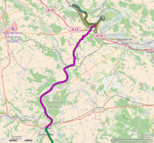
I managed to find a slightly less steep way back down and retraced my steps. Here, mapped out in all its horror, is the map of the last bit of the detour.
I lie this has none of the real horror of the earthy bank. If you bring the full power of your imagination to bear, I think you can see in that loop at the bottom, me climbing the bank, getting to the top and into the field (I think it has or had been used as go kart track, hence those dotted tracks), and looking across to to the now visible dual carriageway behind it’s fencing. If your imagination adds some foul language and near tears it’s not exaggerating but in your mind’s eye, following the loop of those yellow arrows to the right, you can see me tracking through the field with a now almost audibly grumpy Toto-to-be sulking under my tired hands, as we looked for a safer way back down. You can see the sharp little turn where we eventually found an easier route down, and you can see us retracing our steps.
By now Toto-to-be was absolutely not impressed with the whole madness of this trip and I could tell there were mutinous mutterings like “Should have got a damn mountaing bike … and probably some crampons and climbing rope. Dunno what a quality road bike like me is doing in this squalor.”
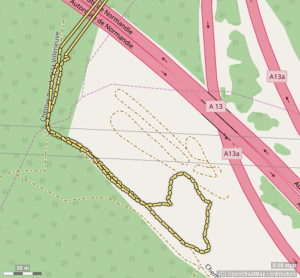
Not only does the map lie in failing to convey any of the true contour line horror it should, it also shows my tracks crossing over the dual carriageway on a bridge. Hence those of you who have been visualising all this, rejoining in the pain and terror of it all, might well be thinking that going over that bridge might of warned me that the audible road noise wasn’t going to work out well as a destination.
Well the map lies as that apparent bridge was a long and very dark tunnel and that point the trees were thick and I’d had no sense that what was above the bridge was a road, I remember having thought that it was a railway line, though I don’t know why I thought that.
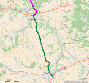
If I zoom back out you can see the whole damn detour.
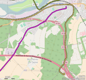
The tracks change colour from yellow to purple as for some minutes I turned the Garmin off there and sat, pretty disconsolately on a wall at the side of the road. I sat and savoured my nettle stings, scratches and a few mosquito bites from that detour through the woods and rather mechanically ate something and psychologically licked my wounds knowing that I had lost well over an hour in all that and was now going to be very hard pushed to make it to Chartres and certainly couldn’t afford any more detours.
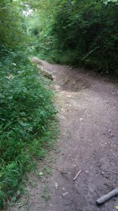
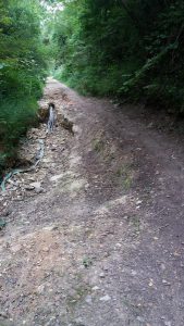
This pair of ‘photos from the sad retracing of my yellow path above shows the quality of the farm track shortly after the tunnel.
Oh boy! Ah well! My will to cycle came back slowly as I chewed, and the day went on much better thereafter.
That, very appropriately purple, track was from the nightmare-in-the-woods to Dreux. It really was a purple patch. The day warmed up without being too hot, it didn’t rain, there were no more seductions and that route was pretty OK I think, though I confess I don’t remember it well at all and have no ‘photos to refresh my memory as ‘photo stops were now out of the question. By Dreux I’d done about 80km and it was late afternoon with 40 km still to go to Chartres and I was decidedly tired. However, I found another supermarket, all the food from Vernons now having long gone. I downed some immediately and, breaking my usual rule, put away a can of beer as I felt I needed analgesia and any psychological lift I could get. I couldn’t see any promising stopping points between Dreux and Chartres but the way looked pretty straight so I booked myself into a B&B in Chartres and, after this stop (below!), I set off as that green track above shows.

Ah, you’re wondering about that orange thing pointing skywards there? It’s a spork: a plastic combination spoon and fork with a serrated edge to the fork end which does fair duty as a knife too. Except when I had really tough meat or cheese the spork conquered most things. For the really tough stuff out came the all powerful Swiss army penknife I’d been given as a leaving present about ten days earlier. I wouldn’t do such a trip without either tool!
I digress, reliving the recharging ten minutes or so there in Dreux. And refueled, off I went on the final green stretch.
So the whole day ended up looking like this:
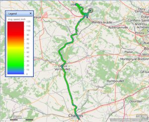
For what it’s worth, the colour coding there is my speed. I think you can see just how slow the detour was, slow patches on some of the hills between Vernons and Dreux, and my exhausted crawl through Chartres at the end of the day. The very cheap, rather horrid sort of mass B&B I’d booked into, the same chain as the one I’d used in Calais, of course turned out to be right on the ring road roundabout on the far side of Chartres! I think it was gone nine in the evening when I got there and I do remember that the place itself was well hidden again. I started to think the chain was taking a perverse glee in hiding from its guests. It turned out to be entirely hidden behind a bigger, somewhat more upmarket competitor which had proper staffing, not just a code you put in on the door. Fortunately the upmarket competitor’s night staff weren’t taking perverse glee in sending people astray and directed round the back yard of their own place to my box.
However, by then I was surfing a rather odd mix of tiredness, perhaps the can of lager, of having emerged from the nightmare-in-the-woodlands after Vernons, and the sheer joy of having had a wide, well tarmaced road almost to myself for most of that ruler straight green stretch between Dreux and Chartres. There had been a wonderful moment on that ruler straight bit of and having seen one of my true pelerinage objectives come into sight against the sunset an hour or so earlier:
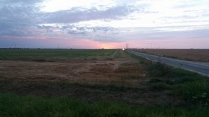
I know it’s a terrible shot, but that was my view, having crested one of the very slight inclines on that glorious cyclists’ road. That dark mark on the sun is Chartres cathedral standing proud and calling me on. 126km at the end of the day and I awarded myself a rest day the next day as I knew I needed at least one day in Chartres. It has the largest, finest expanse of medieval stained glass in the world, in its cathedral. But which few know and perhaps fewer still go to see, it also has the third largest expanse of the same, in a church down the hill from the cathedral. You can’t just whip round that lot in an hour or two and head onwards.
Oh boy, two very different days. Returning to it really brings back some of the worst and some of the best of the trip.
Oh my! The refining fire of pilgrimage burnt fiercely that day. I was looking for something else when google popped this title up. What a perilous business! https://theses.ncl.ac.uk/dspace/bitstream/10443/403/1/Al-Ghamdi93.pdf
Wonderful! I can’t see me reading the whole thesis but lovely to see it. What and how on earth were you searching that you found that Helena?!
I was looking for a vaguely remembered sermon. Not sure of my search terms, I can’t seem to replicate it.
This wasn’t the sermon but it might be of interest, given by the former Dean of Durham: “In the Cathedral there is a monumental sculpture of St James on horseback, brandishing a sword. Underneath are hapless Muslims being massacred – for St James is matamoros, the moor-slayer adopted as the patron saint of the Reconquista, that project of seven centuries to drive Islam out of Spain and reclaim it for Christendom. The cathedral authorities have the decency to hide the lower part of that sculpture with flowers. But it opened my eyes to what I had not appreciated before, that making the pilgrimage in the middle ages was a political act. It stood for the church’s power over another faith community, a power that was brutally expressed in battle and bloodshed.”
https://www.durhamcathedral.co.uk/worshipandmusic/sermon-archive/pullman-pilgrimage
Wow. For me that is a very fine sermon you found there. To a confirmed agnostic who did his own “Condor pilgrimage”, to pick up the name in the sermon, that resonates and perhaps gives me a focus for an overdue post: http://www.psyctc.org/pelerinage2016/going-further-off-piste-with-detours-to-leicester-and-durham/
I’ve known Michael for some years, though he became dean after I left Durham. He’s deeply thoughtful and talks a lot of gentle sense. He blogs too: http://northernwoolgatherer.blogspot.co.uk which he started post retirement, though he also blogged while dean of my favourite cathedral: http://decanalwoolgatherer.blogspot.co.uk