One of my plans for my semigrant life was to have a bike up here and one that could go off road fairly happily but wasn’t so heavy that I wouldn’t be able to cycle up from the valley. I had been saying for a decade or so that the climb is the height of Snowdon so I was clear that any mountain bike had better not be too heavy. Between the last two posts, on Monday before getting the taxi up here, I’d gone into Decathlon and opted for a full suspension mountain bike as it felt it would be much better for the off road and wasn’t much heavier than that “stiff tail” half suspension equivalent. I ordered some other things and agreed that I’d be back yesterday.
So shortly after eight I set off to leg it down the mountain. My garmin seems to have given up on me (very frustrating and I can’t say I recommend them as it has done this a number of times, now perhaps terminally and losing any data from yesterday). This is Google to rescue.
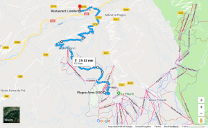
I’ve amended one of Google’s suggested routes down to get a fairly accurate reflection of my actual route. I like the map as it shows the ski lifts. If you click here I think you’ll get that map and can zoom in and pan around and switch it to satellite/aerial photo mode.
I’m intrigued to see that the stretch to Montalbert, the lowermost bit of the ski domain below me here was about half the total distance, both the horizontal distance and the vertical drop. When I got back up here yesterday and before looking at the map again I would have said that it was only about a quarter of the trek. I guess I was already getting tired by the time I got ther, also, from there on all tree and cloud cover had gone and it was roasting and hard on the feet as it was on metalled roads not footpaths and meadows.
Here’s the view of Aime2000 behind me probably 400m into the descent.
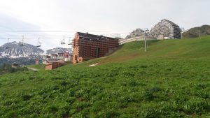
In the ski season to us that’s “golf”, a blue run down to the top of a number of other runs and a lift back up. Looking the other way yesterday I had this:
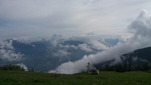
Mont Blanc was poking through and that cloud beneath it looked bizarrely like “Starship Enterprise” (no, I’m not a trekkie!)
Well it really was a hard walk down: 1,485m of descent in 15.9km, i.e. 9.3% mean gradient. Around halfway, by Montalbert, or talking with a lovely elderly lady in Longefoy who greeted me warmly and advised me to take a more scenic (though longer) route, I was telling myself that maybe one day I should do some of the camino on foot rather than on a bike. By the bottom I was just putting one foot in front of the other, had blisters on my heels and ominous soreness in the little knee extensor muscle tensor fascia lata at the top of both thighs. I guess I don’t walk much in my London life. I was doubting whether I could do the cycle back up, let alone walk long distances again in my life!
I went straight back to the lovely Restaurant l’Atelier (see “The semigration has finally started: transition“) and had a lovely lunch with two beers, two coffees, and an alcoholic, ultracalorific pudding to both anaesthetise me, stimulate and fuel me and stifled thoughts that such a concoction was probably what led to Tom Simpson’s tragic death in the Tour de France in 1967. (Actually, as was not unusual then, he had taken a lot more that you certainly wouldn’t get in the Restaurant l’Atelier, though not the designer drugs that blighted the noughties and earlier this decade even, see https://en.wikipedia.org/wiki/Death_of_Tom_Simpson.)
I limped down to Decathlon, got the bike and other things I needed, and a few more things from the huge E.Leclerc hyperarket next door, and I was off on the long climb back very relieved to discover, as I’d hoped, that you don’t use tensor fascia lata cycling nor do you put any weight on your heels.
Some among you (what do I mean “you”? do I need a “you”, yes, I think I do but no pressure). OK, the hawkeyed, geekily knowledgeable, and probably also good at metric/imperial conversion, may have noticed that earlier I said “the height of Snowdon” and then “1,485m of descent” and may have smelled a rat. (Hm, not sure about the metaphor there but I’m tired from all this: let it be Chris!)
Yes, Snowdon us officially 3,560ft (I had always had 3,300 in my head: more rats) and yes, that’s 1,085m and, rats, 1,485m is quite a lot more than that, nearly 50% more as you can see. The taxi driver had said “1,400m” on Monday and a niggling feeling had set in then but, as there was no way I could shrink it, I’d put that out of mind. Interestingly, I can’t get google to draw my cycle ride back up by asking for cycling routes as it creates a number of, to my mind rather implausible looking off road routes and there was no way I was trying that with a moderate weight on my back and the then state of my legs. If I ask for a car route I do get it.
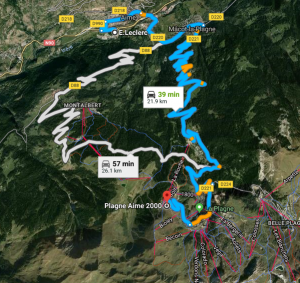
I was doing the blue route (must find that white one some time, might be an interesting challenge on the bike!) Well, as you can imagine, it’s pretty much 1,485m as I had failed to find any way to shrink it.) It only took me seven stints with rests in between! The Garmin has finally deigned to wake up and collaborate though it’s completely lost the data from the walk down, it has got the first two stints of cycling up (it was on the second stop that it died: feeble, if I could keep going it most certainly should have).
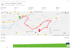
I don’t suppose that’s readable but it shows I did only 3.67km before I had to stop, I’d climbed 231m, burned 260 calories of that lunch (it thinks) and all at a humiliating speed of 5.9kph (yes, that’s kph, not even mph). It had taken me 37 minutes and you can see from the green elevation map that the climb had been pretty steady 6.3% gradient: that was going to get quite a lot worse higher up where the kilometre markers reeled off the distance, height and the gradient, which never dropped below 7% after that and topped out at a nasty 10%. At that point it was already clear that it was going to be a long, slow afternoon! However, I am intrigued when I look at the next bit of the garmin output where I’d reminded it it was supposed to be picking up heart rate.

So another very steady gradient, this time only 27 minutes in which time I’d covered a mere 2.34km, burned another 335 calories and only climbed another 199m but with an average gradient now of 8.5%. It’s the heart rate that amuses me:
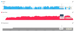
The blue is the speed and it lies, I didn’t really stop completely until the end but by the look of it at times I was moving so slowly that the garmin couldn’t tell the difference (I think that’s another garmin error actually, it shouldn’t be that insensitive). The grey is temperature, still going up, and the red is my heart rate and there you can see that I took a little while to remember to stop the garmin recording. It peaks at 164bpm with a mean of 157bpm. Hm. No wonder I was having to stop. After that the garmin gave out but I did keep going though with at least four more stops, nearly a litre of orange juice, and a couple of glucose/fructose tablets to counter the burning off of available calories.
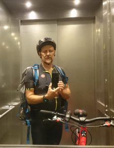
That’s a very tired but relieved me and the, as yet unnamed, bike in the lift that gets you into Aime2000.
So obsessional, so martyrish and sad, so what?! Good questions, fair points!
Well it really did reconnect me with doing my first pelerinage/camino about two years ago, and starting this blog. I remember thinking on that ride “A cyclist [human] is a machine to convert food to distance” (partly to excuse how much nice food I was eating). I have just gone back and looked at some of my blog posts from those early days and see how few were about the cycling and how many were more political or reflective. That’s work, and work on myself, I hope to get back to more in my isolation up here. For now, I think I needed to mark yesterday as a key point in the semigration. Now it’s not so much “have bike: can convert food to distance”, it’s “have bike: independent again; maybe do more thinking as well as some cycling around”.